Less wind, but cold Friday morning
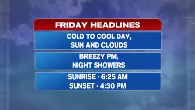
The strong, damaging wind threat is behind us for now as the wind continued to subside through today. Check out some of the peak gusts from last night. The wind continues to decrease tonight and stays light through tomorrow morning. The wind relaxes as low pressure continues to move farther away from us. A secondary cold front was draped across southern New England this morning. Behind this drier air will continue to work in allowing temperatures to really drop overnight. It will be a cold start tomorrow morning with temperatures dropping into the upper 20s. After the cold start, temperatures will rebound into the low 50s under a mix of sun and clouds. A southwest breeze picks up by the evening. An Alberta clipper will continue sweeping east tomorrow bringing us our next chance for showers Friday night into early Saturday morning. Showers slide in from northwest to southeast past 8 pm tomorrow. The system is progressive and out of here by the time most of us wake up Saturday. Saturday is our mildest day with highs in the low 60s. That’s slightly above our normal high of 55° in Boston. There won’t be a lot of wind this weekend, so we can take a break from that. Highs will be closer to average in the mid/upper 50s Sunday. Some other highlights of the 7-day forecast… Another clipper system brings our next chance for showers Sunday night into Monday morning. Veterans Day will start off cold and stay blustery. -MB