Limited rain chances in the forecast
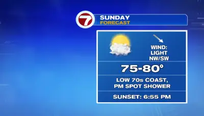
Good morning! It’s another cool and comfortable start for us. Temperatures are already warmer compared to this time yesterday. Our cool morning will lead to a warm afternoon with highs returning to the upper 70s inland. Some towns could hit 80° if you get more sunshine. Temperatures on the coast will be in the low 70s. There’s a cold front around Northern New England that will get closer to us today. That front along with upper-level energy will bring a 20% chance for a spot shower this afternoon and evening. Rainfall amounts will be light. There’s a low risk for lightning. Rain chances will be limited this week. Tomorrow and Tuesday are dry days. An area of low pressure currently off the Carolina coast will be slow to make its way up the coast this week. That will bring us some showers from the south Wednesday night into Thursday. Again with this, amounts look minimal. Outside of limited rain chances, the other weather headline will be the warmth this week. High temperatures return near 80°. A cold front late Friday knocks back temperatures into the start of next weekend. But wow, will it feel nice with dewpoints expected in the 30s! We’ll be in a fall-like feel before Astronomical Fall officially begins the following Monday. -MB