Major wind ahead for Wednesday night
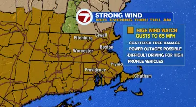
Batten down the hatches! A very windy night is ahead Wednesday night into Thursday morning. Even before then, breezy conditions will dominate. First, overnight Tuesday into Wednesday will be a cold one again. Lows will drop to the mid 30s, so make sure you’ve got your winter coat once again. Clouds will be on the rise as the morning progresses on Wednesday. The wind won’t be too bad during the day, and highs will reach the mid to upper 50s. It’s Wednesday night that the wind will begin cranking. While many wind gusts will reach 35-45 mph, into early Thursday morning they may peak much higher. In many instances, we could see gusts topping 60 mph, especially along the coast and on the Cape and the islands. The National Weather Service has issued a high wind watch for Wednesday evening into Thursday morning for the risk for tree damage, a few power outages and a warning that driving in high profile vehicles may be difficult. We’re also tracking a line of rain Wednesday night as well that will leave behind clear skies for Thursday. Thursday will be windy and brisk. Morning lows will drop to the low 40s, with highs in the upper 40s and low 50s. Skies are looking mostly to partly sunny. Get ready for a big chill Friday morning! Lows will get all the way down into the upper 20s. It will be one of the coldest mornings so far this fall. Friday during the day will be dry with highs rebounding into the low 50s. We do have our next chance for some rain Friday night into Saturday. Because of that rain chance, lows Saturday morning won’t dip too far to the upper 40s. Highs Saturday will reach the low 60s and we’ll dry out toward the second half of the day. To round out the weekend, Sunday will be on the cloudier side with morning temperatures in the low 40s and afternoon temperatures into the upper 60s. Next week, Monday: partly sunny upper 30s to upper 40s. Veterans Day is Tuesday and it will be bright but cold and windy. Lows will drop to the mid to upper 20s with highs near 40.